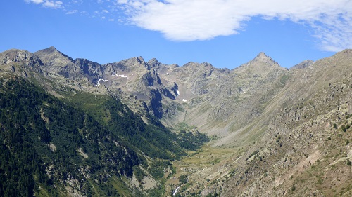
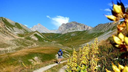
Ideas for walks and day trips to discover the Stura Valley. Excursions can be made at ani time of the year, otherwise it is specified at the beginning of the sheet.
Many routes can also be made after snowfalls, as they do not have areas and/or passages with avalanche danger. In none of these itineraries is referenced as snow to ski mountaineering which has completely different dynamics and characteristics of routes. Children’s routes never have technical passages, difficult and exposed, they do not have a length of more than 8 kilometres and never exceed 400 metres of altitude difference. For these characteristics they therefore suit all children. (At the discretion of the parents, if the child is trained, he can do others as well).
![]() Excursion also suitable for children
Excursion also suitable for children ![]() Possible excursion with snow
Possible excursion with snow
![]() Excursion NOT suitable for childreN
Excursion NOT suitable for childreN ![]() Excursion NOT possible with snow
Excursion NOT possible with snow
![]() summer
summer
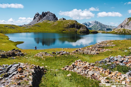
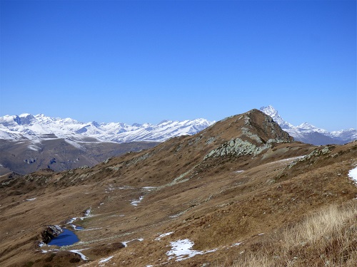
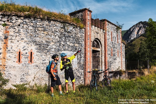
Vignolo or Cervasca: Colletto Mount | |
Length: 7.6 km |
|
A ring path between chestnut groves and ancient hamlets that winds along easy attended dirt roads and on the paths of the first valley peaks directly overlooking the Cuneo plain. A perfect itinerary to take un half a day, to do perhaps in the company of your four-legged friend. Going up from Vignolo or Cervasca, we start on foot from the Aranzone hamlet. We follow a dirt road through chestnut woods to Pra d’Franca and Pertus of Colletto. From here on a path, sometime steep, we go up keeping the ridge up to Monte Colletto, a wonderful panoramic terrace. Then we go down towards Pra Gaudino and again on the path you return to Aranzone. |
|

Borgo San Dalmazzo: Croce Mount and Saben Mount | |
Colla delle Piatre; length: 9.3 km Saben Mount: Length 11.6 km Croce Mount: length: 3.8 km |
|
A walk that develops entirely on the ridge between the Stura and Gesso Valleys in the middle of medium mountain woods with birches, ash trees and cherry trees, and then passes to beech forests and stretches of panoramic grasslands.
|
|
Rittana – Paraloup Hamlet: Rittana Alp and Beccas del Mezzodì | |
Rittana Alp: length 5.6 km Beccas del Mezzodì: length: 8.5 km |
|
One of the most beautiful places in the lower Stura Valley. We start from the Paraloup hamlet and after a few minutes in the woods, we walk on a path among flowering meadows up to 1800 metres of the Rittana Alp. For those who want to continue, the hike proceeds on a downhill route towards the Roccasson Hill and then again uphill to the Beccas del Mezzodì, an iconic peak that divides the Stura Valley from the nearby Grana Valley. From Paraloup we go up a steep dirt road, which in a few minutes becomes a path. Without the possibility of error, continue uphill until you reach the plateau of the Arpiola Cross. From here uphill again steep to the rounded top of the Rittana Alp. To continue we go down to the collar, go up again to where the path moves on the side of the Grana Valley. Here we keep the right and in short you reach the Beccas del Mezzodì. |
|

Rittana o Valloriate: Tajarè Mount | |
|
|
“If you asked a child to draw a mountain, he would draw it like Tajarè Mount”: a sharp peak with the woods at the base and rocky at the tip. A mountain symbol of the lower valley, which although very pointed, is quite easy to reach. Starting from Chiotti di Valloriate, we take the path towards Cavagna and immediately turn left towards the top. Without the possibility of error, we get to the summit cross. From here we can return or continue to the “meadows of Napoleon” and close the ring returning to the side of the “Ubac”, on an ancient mule track among mixed woods. The top of the Tajarè can also be reached from Paraloup, with a shorter itinerary than described. |
|
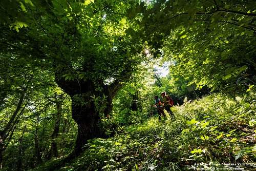
Valloriate: The Monumental Chestnut | |
|
|
If you want to discover the lower valley, once at least. You need to “get lost” in its chestnut woods. This is a walk suitable for everyone and has as its destination the spectacular Valloriate Monumental Chestnut. |
|
Gaiola: Giro dei Soffioni and the Bric Rora | |
|
|
Perfect excursion for every season and suitable for everyone. We almost always walk on a comfortable dirt road that allows us to calmly gain altitude and with an increasingly beautiful panorama as we climb. We discover the curious “Soffioni” of Gaiola, karst cavities characterized by continuous hot air breaths, particularly visible in winter. |
|
Moiola: Chapel of the Crowned and Chris Bangle’s “Big Bench” | |
|
|
An excursion which is also a historical journey: in fact, we follow the “Via d’la Maona”, in the past the pilgrimage route to the little church. The chestnuts undergrowth will accompany us for most of the itinerary. |
|
Demonte – Sant’Anna of Rialpo and Monte Croce dell’Ubacco | |
|
|
The ancient climb to the “Colle del Bal” was used in the past to reach friends and family of neighbouring countries and here stop to celebrate the meeting. The route, all on the path, leads to discover the passage of the “Colle Donnarena”, the place where it is said that “Dona Rejna”, who is the Queen Giovanna d’Angiò, used to retreat during her (possible) stay in Stura Valley. |
|
Demonte – Bergemolo: Cialanca Peak | |
|
|
Starting from the meadow basin of Bergemolo, where we can admire its centuries-old elm, we walk towards the Pra of Sala and “Colle dell’Arpione” and then face the last climb on the ridge to the top; all under the imposing rocky massif of Mount Bourel. |
|
Demonte – San Giacomo: R. Bernadi Bivouac and Bram Mount | |
|    |
The famous “cumba”, a paradise for winter ski mountaineering, turns in summer into a valley with flowery slopes kissed by the sun. An itinerary that leads to the recent Bernardi Bivouac as well as mirroring itself on the Bram small lake. The ridge path is part of the long ring ride, the “Curnis Auta” that surrounds the Grana Valley. |
|
Length: 8.2 km Length: 13.4 km |
|
The name is a proof of that. If you are looking for a path suitable for everyone, surrounded by beautiful high mountain blooms, you must try this route. You can discover the first part and then go back or go down to the Carbonetto Hut (you must organize yourself with cars, but it is worth it), or complete it with a ring ride around Omo Mount and Salè Mount. |
|
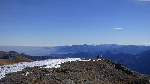
Demonte: Black Beak and Meja Lake | |
|  |
A very simple ring that develops in a unique environment, always over 2300 metres above altitude. The magnificent “Rocca la Meja”, the “Stone Queen”, seen from the Black Beak, is worth the day alone. A ring suitable for everyone, almost entirely on high-altitude dirt roads. With the only ascent on the path to the Black Beak, rather easy. From Valcavera Hill we walk towards the Bandia and immediately before we go up towards the “Colle di Ancoccia”; from here on a path towards the Black Beak and then descend to the lake (pink notches on the rocks). We Continue downhill towards the Margherina Hill, where we meet again the main road again and return to the Bandia. |
|
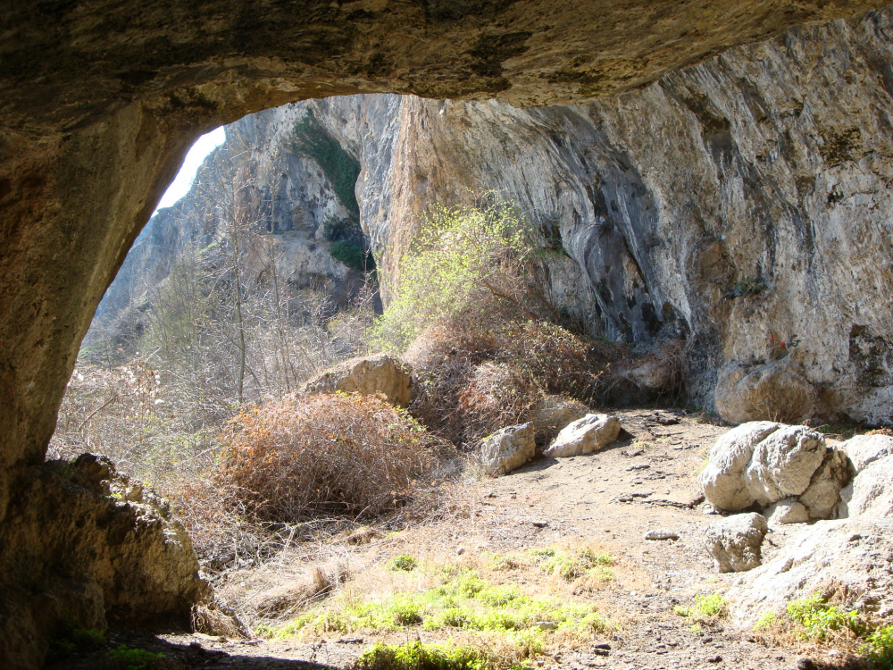
Aisone: Aisone and Pirone Caves | |
|
|
A route entirely on the side in the sun, therefore perfect in spring and autumn. A journey to discover ancient hamlets, straw roofs and the “Neolithic” caves of Aisone. |
|
Vinadio: Neghino Fort | |
Length: 6.1 km |
|
An easy path suitable for everyone that follows a perfectly preserved military road up to the plateau of Neghino Fort; one of the few elliptical plans that offers a unique view of the valley. The excursion can be tackled in a ring or round trip (simpler). We start from Vinadio and, passing through the Neraissa gate, go up to the valley of the same name. From the Church “Madonna del Vallone” we go up the path, quite steep but shirt, until we intersect the easy path that in a shirt way leads to the fort. It is recommended to look out over the floor behind the fort to see Vinadio from above and the Sant’Anna of Vinadio Valley right in front. The descent develops on the military access road (which is done uphill and downhill if you want to make the round trip). |
|
Vinadio: Nebius Mount | |
Length: 9.8 km | |
Long and steep climb, but the Valley of Neraissa from which we start and the beauty of this symbolic mountain pay off widely for all efforts. |
|
Vinadio - Sant’Anna di Vinadio: Tour of the lakes | |
|
|
A classic ring of the Stura Valley, but so beautiful that is redone every year. We star from the “Sant’Anna di Vinadio” Sanctuary and between narrow streets and paths we fallow a ring path that touches hill and mountain lake. |
|

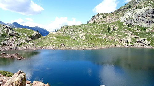
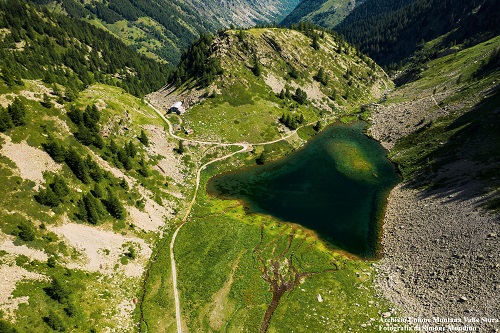
Vinadio: Malinvern lake and Valscura Collar | |
To the Refuge: To Malinvern lake: To Valscura Collar: |
|
In the Rio Freddo Valley, the imposing rocky massif Malinver Mount, which accompanies us for the entire climb. The dirt toad is easy for the Malinvern Refuge, from which the path begins, sometimes steep, to Malinvern Lake. For those who want to continue, going up to the Valscura Collar you get to overlook the nearby Gesso Valley and the Maritime Alps Park. From the paved parking lot, we go up on a dirt road, always straight up to the refuge. From here we continue following the hiking signs. The rout is quite long but can be shortened by stopping at the refuge and from the refuge itself. Many other possibilities open for numerous excursions. |
|
Vinadio - Vinadio Baths: VacciaMount | |
|
|
While facing the climb, hard, steep and full of hairpin bends that allow us to gain altitude quickly, you can’t imagine that everything changes up there! In fact, we arrive on a wide prairie side that with gentle slopes leads to the summit. The view ranges at 360 degreed on the valley and its side valleys. |
|
Vinadio – Vinadio Baths: Migliorero Lake and Refuge | |
Length: 9.7 km |  |
If we were to find a “super classic” of the valley, it would be this! A regular climb to the large basin that leads, almost flat, to the refuge and its lake surrounded by some of the most beautiful peaks of the valley. |
|
Vinadio: Becco Alto d’Ischiator | |
Length: 15.0 km |
|
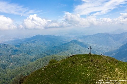
Actually, this is the continuation of the previous excursion but given its importance it deserves a card on its own. Traveling through the Stura Valley to Vinadio you will always see, there at the bottom, the sharp top of this mountain. The climb is very long ad it provides for a long approach phase passing through the Migliorero Refuge, from where the real difference in height begins. The climb, although steep, is never too difficult and does not include climbing passages. The summit reaches 3000 metres and offers a unique view that on lucky days allows you to see the whole valley up to the plain. |
|
Vinadio – Vinadio Baths: Saint Bernolfo, Laus, Collalunga and Autaret | |
Length (round trip): 18.1 km Length (ring); 21.0 km |
|
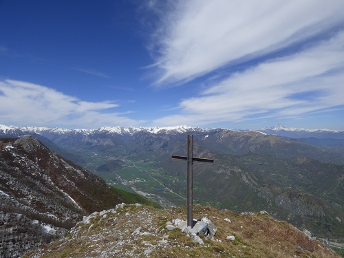
If you want to see one of the most spectacular military roads in the entire Alpine arc you must try this excursion! Alpine lakes, unspoiled nature, fortified works and a unique panorama of the Maritime and Cottian Alps. (Children, but only at Laus Lake)
|
|
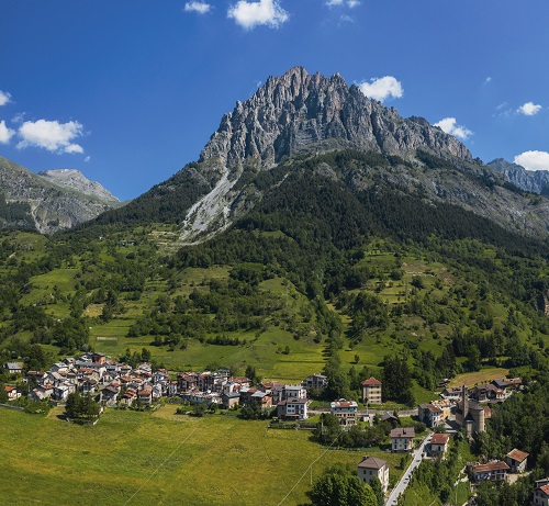
Sambuco: Bersaio Mount | |
Length (round trip): 14.6 km Length (ring): 19.1 km |
|
| What is the natural symbol of the Stura Valley? Many will answer “Bersaio Mount”. A spectacular mountain! Rocky and impervious the slope on Sambuco, grassy and sweet on the opposite side. To reach its summit, we follow the Madonna Valley, to “get around” the mountain and get there from the north; once up there, it feels like you are flying! We start from Sambuco and climb almost immediately on the path, flanking the stream and its gorges. Once at the Gias, we cross the river and continue towards west, pointing at the hill and crossing the grassy slopes. Once at the hill we drift towards south to the top. For the return we can return on the ascent route or go down to the west, looking for the road that winds lower. A little further on starts a downhill path that connects to an important dirt road. From here you arrive in Moriglione and return to Sambuco. |
|
Pontebernardo – Murenz village: The Red Beaks | |
Length; 9.1 km |
|
More than a hike in the mountain! A real leap into the history. Along the entire climb we can see fortified works built between 1700 and the beginning of the 1900s everywhere. The Red Beak is a “rocky beak” entirely excavated to house a military fortification that offers a unique view of the upper valley and the Ferrere Valley. |
|
Pontebernardo – Sambuco: The Ecomuseum of Pastoralism paths | |
Pontebernardo – Castello: h 0.50: total difference of height: 325 m. Pontebernardo – Pietraporzio: h 1.00; total difference of height: 412 m. Pontebernardo – Moraglione San Lorenzo: h 2.00; total difference of height: 575 m. Pontebernardo – Sanbuco: h 3.15; total difference of height: 827 m. |
|
The Stura Valley has obvious differences between the two sides. The orographic right, exposed at midnight, the “Ubac” in Occitan, has slopes covered with dense fir and larch trees and is furrowed by deep valleys rich in water. The left side, the “adrech”, the sunny place is the kingdom of the scots pine and aromatic herbs that adapt to a drier soil. The paths develop on this side and run, halfway up the slope, the stretch between the Barricades gorge, a natural rock barrier overlooking Pontebernardo and the “Dolomite” walls of Roùcha Biancha (Bersaio Mount), whoch rise above Sambuco. |  |
Pontebernardo – Ferriere: The Smuggler’s Ecomuseum Paths | |
Pontebernardo – Ferriere: h. 3.30; toatl difference of height: 1045 metres |
|
The Ecomuseum of Pastoralism offer the paths on the tracks of shepherds, farmers and smugglers to admire suggestive landscapes and discover the signs left by man on the terrotory. The path from Pontebernardo to Ferriere develops between the districts of Pietraporzio and Argentera. The departure is the town of Pontebernardo; following the ancient mule track that climbs the steep slope, we cross the Murenz hamlet, the locality “Lou Quioùot de la Loubìera” and some fortified cave works of the 1940s. |
|
Argentera – Ferrere Hamlet: Colle del Ferro and Vens lakes | |
Length: 15.3 km |
|
| Another of the “must” excursions of the Stura Valley that encroaches on French. A long Alpine valley, a natural arch and lakes among the most beautiful in the Maritime Alps. Starting from the charming Ferrere hamlet, we face the climb along the Forneris Valley, towards “Colle del Ferro”. Once at the hill, we begin the descent in France passing next to the “Arc the Tortisse”, a spectacular formation in the shape of a natural arch created by erosion, and then we descend on the Vens Lakes, which suddenly appear with their incredible blue colour |
|
Argentera – Ferrere Hamlet: Colle del Puriac and Enchastraya Mount | |
Length: 14.7 km |
|
Another wonderful excursion starting from Ferrere. The mountain “drawn” by sandy rock layers accompanies us along the entire path and is conquered with a demanding climb. The summit is a long ridge, at most 3-4 metres wide overlooking all the western Alps. (children up to “Colle del Puriac”) |
|
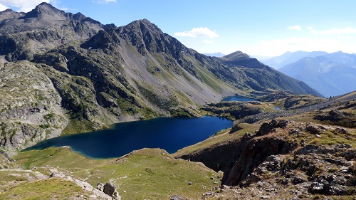
Argentera or from the Colle della Maddalena: Roburent Lakes | |
Length (Colle della Maddalena): 12.0 km Length (Argentera): 13.0 km |
|
The cover photo oh rh Valley is certainly that of the Roburent Superior Lake seen from the homonymous hill! Two possible climbs, both on the path, to discover a rocky environment that is mirrored inside bright blue lakes. We can start from the “Colle della Maddalena” towards the Oronaye Valley (simpler) or from the concentric Argentera and arrive on the other side, first discovering the two lower lakes (more challenging). |
|